Home
Home
Information regarding GPS
One of the key features of the Tangent Flight Computer is it's ability to use
information from a GPS (Global Positioning Satellite) to provide key
information for cross country flight. Arai Design is a dealer of Garmin
handheld GPS units and we also sell several accesories for using GPS with the
Tangent.
You will find the following on this page:
-
GPS Bracket for Hang Gliding
-
Velcro bracket with sturdy aluminum plate. Allows access to data port.
View a picture
-
Garmin to Tangent data cable
-
Available in custom lengths.
How
to Choose a Garmin Handheld GPS for Hang Gliding and Paragliding
As a Garmin dealer, we often get asked our opinion
on the difference between the various Garmin handheld GPS models and
thier suitability to our gliders and our vehicles. Since I last updated this
article the GPS models available have changed dramatically. As we have become
acustomed to in electronics, features have grown, power consumption has
diminished and prices have dropped.
In the past tradeoffs had to be made for durability and receiver performance.
That is no longer the issue, as all of the Garmin handhelds are using very
efficient 12 channel receivers. While some models might perform better in a
car, all models will work superbly in the air. The choices come down to
features vs cost.
This article covers the following:
For use in a hang glider or paraglider:
For flying only (or infrequent use in the car,)
the economical choice is the Garmin GPS 12. It is the lowest cost, most durable
and it works great. It comes with an internal antenna, which is much prefered
over the external (I cynically call them break-away) antennas of the 48 and
III+ . The GPS 12 has no ability to connect to an external antenna, so it is
not the best choice for use in a car, but experience shows that it works quite
well on the dash of most vehicles.
The deluxe choices now are the handhelds (GPS Map, GPS III+, eMap) with
downloadable maps that display
right on the unit. While these maps are a little difficult to read in detail
in the air, you can at least tell your crew what town you are near, which is
much easier than coordinates for chasing while you are in no danger of landing.
Of course difficult retrieves will always require coordinates.
These units allow for downloading of custom sections of map and provide a lot
of detail. They even have the ability to display topographic information,
although I don't recommend trying to read it in the air, at least not in my
gaggle!
There are currently three map units available that I would consider for flying
use: The GPS 12 Map GPS III+ and the eMap. The GPS 12 Map is the best
choice. I don't recommend the GPS III+ - which was
the first map capable unit available and became quite popular - because of it's
external antenna and it's odd form factor (shape.) The eMap has potential, but
I haven't tried it yet. At this time I can only
provide some basic information as I have not had a chance to fully evaluate
them. I will be doing that in the near future.
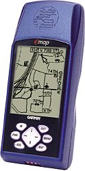 eMap
The eMap is the low cost unit, and while it has some interesting features -
a bigger display, more memory and
lower cost than either the GPS 12 Map or the III+ - it has some serious
drawbacks. It only uses 2 instead of 4 AA batteries, giving it a
manufacturer's stated battery life of only 14 hours (on 2 cells) as opposed to
36 hours (on 4 cells) for the 12 Map or the III+. The other drawback is a less
water proof case, which probably also means less durable. The other drawback
is limited
route capability. See the
GPS Feature Table
for specifics. Also see
Read Garmin's statement on Waterproof Standards
eMap
The eMap is the low cost unit, and while it has some interesting features -
a bigger display, more memory and
lower cost than either the GPS 12 Map or the III+ - it has some serious
drawbacks. It only uses 2 instead of 4 AA batteries, giving it a
manufacturer's stated battery life of only 14 hours (on 2 cells) as opposed to
36 hours (on 4 cells) for the 12 Map or the III+. The other drawback is a less
water proof case, which probably also means less durable. The other drawback
is limited
route capability. See the
GPS Feature Table
for specifics. Also see
Read Garmin's statement on Waterproof Standards
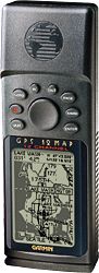 GPS 12 Map
The 12 Map comes in the proven durable and reliable package that the GPS 12
comes in. It has all of the features of the III+: down loadable maps, 4 level
gray display and 36 hour battery life it is lower in cost and doesn't have the
fragile external antenna. It also doesn't allow for rotating the display like
the III+ does, but for flying that is not an issue.
GPS 12 Map
The 12 Map comes in the proven durable and reliable package that the GPS 12
comes in. It has all of the features of the III+: down loadable maps, 4 level
gray display and 36 hour battery life it is lower in cost and doesn't have the
fragile external antenna. It also doesn't allow for rotating the display like
the III+ does, but for flying that is not an issue.
A GPS for your Retrieval Vehical:
There are four choices for use in a car, depending on your budget:
-
The GPS 12
-
eMap
-
GPS 12 Map
-
GPS III+
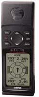 GPS 12
The GPS 12 is the economical choice. It has all the performance needed to
function well as a retrieval unit, plus it's a good backup for flying. It
lacks the map, but in serious retrieve situations it's coordinates you need.
The maps just make it easier. If you load up your car with a canopy of
gliders, then the GPS 12's lack of external antenna capability will have you
hanging your arm out the window. If you have a driver that has been good to
you, then you should consider one of these as a gift. Especially if that
driver has been on a late night retrieve without a GPS.
GPS 12
The GPS 12 is the economical choice. It has all the performance needed to
function well as a retrieval unit, plus it's a good backup for flying. It
lacks the map, but in serious retrieve situations it's coordinates you need.
The maps just make it easier. If you load up your car with a canopy of
gliders, then the GPS 12's lack of external antenna capability will have you
hanging your arm out the window. If you have a driver that has been good to
you, then you should consider one of these as a gift. Especially if that
driver has been on a late night retrieve without a GPS.
eMap
The eMap is Garmin's low cost entry to GPS mapping. It's strong points are
the capabilities of it's map data base. The eMap even allows you to enter an
address to come up with a waypoint! Useful if a pilot's GPS batteries die and
he walks out to a farm house to call his driver on the phone. The eMap will
accept an external antenna. This may be the best choice for a retrieve vehicle
in terms of cost/performance.
GPS 12 Map
This unit can't hold as much data as the eMap, but it can hold all the detail
you need for a likely retrieve on a hang glider or paraglider flight. It is
more durable than the eMap, but it will cost more. The 12 Map will accept an
external antenna.
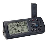 GPS III+
This unit's claim to fame is it's rotatable display. All of the above units
need to be held upright to be read in a natural position. The III+ can rotate
it's display into "landscape" mode, which will allow you to set it on its side
on the dashboard and easily read it. It has the exact same mapping
capability as the 12 Map and it too accepts an external antenna.
GPS III+
This unit's claim to fame is it's rotatable display. All of the above units
need to be held upright to be read in a natural position. The III+ can rotate
it's display into "landscape" mode, which will allow you to set it on its side
on the dashboard and easily read it. It has the exact same mapping
capability as the 12 Map and it too accepts an external antenna.
USING NICAD BATTERIES IN THE GARMIN HAND HELDS.
My personal philosophy is to forget Alkalines. They are wasteful
and expensive in the long run. Nicad batteries are the way to go. You can
buy high capacity Nicads for about $15 for a set of 4 and they will last
the life of your GPS. Make sure you get batteries that are at least 800mAhr
capacity. Nicads can be found that have capacity of up to 1000mAhr that give
you a few more operation.
A newer battery technology known as Nickel Metal
Hydride (NiMh) is available with capacities of up to 1300 mAhr. They are
not my preference as they are more expensive, don't perform as well at
low temperatures and have very quick self-discharge (they run down even
when not in use.) In addition they require special chargers because they don't
tolerate overcharging as well as Nicads. The are probably better suited to
pilots flying in warmer climates. If you want to use NiMh batteries, I
recommend that you get a charger with zero slope (prefered) or peak voltage
detection as a method of charge termination, as well as a low trickle charge
rate. Without these precautions you are likely to see greatly reduced service
life from NiMh batteries. Aside from saving the batteries, this sort of
charger will allow 1 hour charges. You will find the best source for this sort
of charger is the radio control hobby catalog. Electric R/C cars in particular
use these chargers.
|
Feature
|
GPS 12
|
GPS 12 Map
|
GPS III+
|
eMap
|
|
Battery Life Alkaline (1)
|
24hr
|
36hr
|
36hr
|
14hr
|
|
Battery Life Nicads
|
9hr (2)
|
13.5hr (2)
|
13.5hr (2)
|
6hr (2)
|
|
Ext. Voltage
|
5-8 V
|
10-40V
|
10-40V
|
2.5V
|
|
Track Points
|
1024
|
1900
|
1900
|
2000
|
|
Waypoints
|
500
|
500
|
500
|
500
|
|
Routes
|
20
|
20
|
20
|
10
|
|
Map Memory
|
n/a
|
1.44MB
|
1.44MB
|
8 or 16MB
|
|
Down load maps
|
No
|
Yes
|
Yes
|
Yes
|
|
Screen Orientation
|
Vertical
|
Vertical
|
Vert/Horz
|
Vertical
|
|
Screen Color
|
B/W
|
4 level gray
|
4 level gray
|
4 level gray
|
|
Pixels
|
64x100
|
100x160
|
100x160
|
120x160
|
|
Antenna type
|
Internal
|
Internal
|
Detachable
|
Internal
|
|
Ext. Ant. Opt.
|
No
|
Yes
|
Yes
|
Yes
|
|
Weight
|
9.5
|
9.5oz
|
9oz
|
6.7oz
|
|
Size
|
2.1x5x1.2
|
2.1x5x1.2
|
2.32x5x1.62
|
2.4x5.5x.8
|
|
Waterproof (3)
|
IPX7
|
IPX7
|
IPX7
|
IPX2
|
|
MSRP
|
$231
|
$425
|
$571
|
$299 (8MB)
|
|
Arai Design
|
$150
|
$335
|
$350
|
$290
|
(1) Manufacturers Specs.
(2) Run time is extrapolated from the GPS 12 Nicad run time, which is
measured.
(3)
Read Garmin's statement on Waterproof Standards